Did you know that the NSW Low and Mid Rise policy doesn't always exclude flood-affected properties? You'd have to read rules and maps very carefully to understand when.
This exclusion list for LMR mentions "flood prone land" or land in a "flood planning area". So people might have assumed that any flood-affected property can't benefit from higher density near stations/centres nor the statewide dual occupancy permissibility in R2.
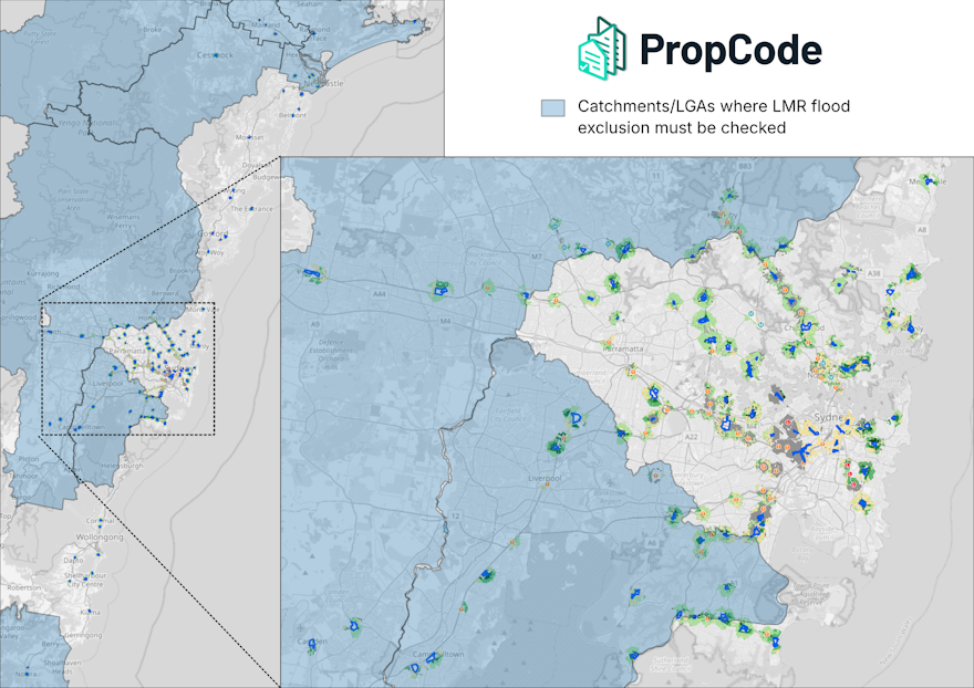
However there are specific geographic scopes given for these flood exclusions: only within the Hawkesbury-Nepean or Georges River catchments or a list of regional LGAs. (See Housing SEPP s164 (f),(g))
When you plot these geographic areas on a map (see above), you see that in fact many parts of Sydney, Central Coast, and Illawarra are not affected by the flood exclusions at all!
Broadly speaking, across most of eastern and central Greater Sydney plus Central Coast and Illawarra, a property still gets the LMR benefit even where it is flood affected.
But flood exclusions must be checked around the edges of Greater Sydney and across all of the Hunter and Shoalhaven regions, as well as elsewhere in regional NSW.
Note that for Hawkesbury-Nepean and Georges, the exclusion operates on "flood prone land" meaning anything up to PMF. But for the listed regional LGAs, the exclusion is for “flood planning area” which is defined by each Council and usually correlates to the 100-yr (1%) flood extent.
Although the Department offers indicative mapping of LMR catchments on their website, it does not consider any of these granular details written into the rules, so further research is definitely necessary!
![[object Object]](https://umsousercontent.com/lib_heZDZMqkJicLuLKJ/igzynodna381foma.png?w=358)
Menu
- Our Platform
- Pricing
- Contact Us