![[object Object]](https://umsousercontent.com/lib_heZDZMqkJicLuLKJ/igzynodna381foma.png?w=358)
(posted on 20 Dec 2023)
The NSW Govt's recent proposal to enforce higher density near all transport hubs and centres has potential to transform many places across the state. Check out my earlier rapid analysis on the day of the announcement that assessed the quantum of lots with new permissibility in the rough proposal.
The NSW Govt has now released the detailed Explanation of Intended Effect (EIE) which is required before enacting a SEPP to implement the changes. In this EIE are further details that allow for some more interesting analysis to be done.
If you enjoy this analysis and would like to obtain some of the data or request additional analysis, please contact us.
UPDATE - request an instant analysis for your specific property here!
The Proposal
As in the original announcement, most of the changes apply in the Six Cities Region (Sydney - Shoalhaven - Hunter) to "station and town centre precincts", which are now defined as within 800m walking distance of:
- a public entrance of a train, light rail, or metro station;
- an E2 Commercial Core or SP5 Metropolitan Core zone;
- an E1 or MU1 zone, but only if it contains a sufficient concentration of shops and services.
These are the permissibility changes being proposed:
- dual occupancy permissible in all R2 zones across NSW;
- medium density up to 2 storeys (multi dwelling housing, manor houses, and terraces) permissible in R2 zones within 800m of station and town centre precincts in the Six Cities Region;
- mid-rise apartment buildings permissible in R3 zones within 800m of station and town centre precincts in the Six Cities Region.
The EIE also states that non-discretionary standards for maximum height, maximum FSR, minimum lot size, and minimum width will be introduced for the various residential typologies. These will override any LEP or DCP controls so that DAs cannot be refused on those grounds if they numerically comply with the new SEPP standards.
Dual occupancies and medium density will have maximum height of 9.5m but are limited to 2 storeys by definition. Dual occupancies will have FSR up to 0.65:1 and minimum site area of 450 sqm. For medium density the FSR will be 0.7-0.8:1 and minimum site area of 500-600 sqm, varying by typology.
The most interesting non-discretionary standards are for residential flat buildings and shop top housing. These will be able to achieve 21m height and 3:1 FSR within 400m, or 15m height and 2:1 FSR within 800m, of a station or centre.
Impact of Proposals
But what will be the real world impact of these reforms? How many properties will actually see a change in their permissibility or development standards for these typologies?
I've used PropCode's extensive database of documents and maps to quickly compare existing and proposed permissibility and controls on each individual lot in station and town centre precincts in the Six Cities Region.
To avoid overstating impacts, I have excluded heritage items and conservation areas as well as rural (RU) and environmental (C) zones. I also ignored the E1/MU1 zone in the centre precinct definition due to its vagueness and because the vast majority of Sydney is within 800m of an E1/B1/MU1 zone.
Here are the total affected lots within station and town centre precincts in the Six Cities Region by LGA, split by dual occupancy, medium density (manor house, terraces, multi dwelling housing), and apartments (residential flat building and shop top housing):
| New Permissibility | FSR Uplift | ||||
| LGA | Dual Occ. | Med. Density | Apartments | Dual Occ. / Med. Density | Apartments |
| Bayside | 9,194 | 1,369 | 9,181 | 2,544 | |
| Blacktown | 18,389 | 1,115 | 1,946 | ||
| Blue Mountains | 2,359 | 2,327 | 626 | ||
| Burwood | 1,636 | 64 | 1,636 | 362 | |
| Camden | 615 | ||||
| Campbelltown | 4,237 | 1,831 | 128 | 972 | |
| Canada Bay | 1,965 | 1,963 | 1,137 | ||
| Canterbury-Bankstown | 15,126 | 8,749 | 12,252 | 15,407 | |
| Central Coast | 5,447 | 13 | 1,202 | ||
| Cessnock | 370 | 2,430 | |||
| Cumberland | 10,146 | 3,666 | 6,207 | ||
| Fairfield | 4,374 | 1,002 | 4,374 | 2,251 | |
| Georges River | 9,834 | 441 | 9,811 | 2,878 | |
| Hawkesbury | 978 | 978 | 1,248 | ||
| Hornsby | 9,033 | 9,033 | 3 | 439 | |
| Inner West | 13,835 | 13,835 | 712 | 11,309 | 7,872 |
| Kiama | 1,281 | 233 | |||
| Ku-ring-gai | 3,130 | 3,130 | 87 | 3,126 | 1,107 |
| Lake Macquarie | 5,919 | ||||
| Lane Cove | 1,070 | 1,065 | 243 | ||
| Liverpool | 577 | 577 | 1,491 | 577 | 2,648 |
| Maitland | 58 | ||||
| Newcastle | 2,762 | 5,328 | |||
| North Sydney | 598 | 598 | 734 | 47 | |
| Northern Beaches | 3,331 | 3,331 | 70 | ||
| Parramatta | 3,028 | 685 | 2,919 | 2,108 | |
| Penrith | 1,762 | 1,222 | 156 | ||
| Port Stephens | |||||
| Randwick | 6,441 | 6,441 | 6,420 | 3,546 | |
| Ryde | 5,604 | 5,604 | 5,583 | 657 | |
| Shellharbour | 4,825 | 373 | |||
| Shoalhaven | 1,687 | 262 | |||
| Strathfield | 915 | 915 | 897 | ||
| Sutherland | 1,725 | 15,896 | 4,022 | ||
| Sydney | 1,869 | ||||
| The Hills | 2,361 | 1,974 | 477 | ||
| Waverley | 353 | 353 | 479 | ||
| Willoughby | 1,911 | 1,908 | 714 | ||
| Wollondilly | 1,703 | ||||
| Wollongong | 15,727 | 4,026 | |||
| Woollahra | 312 | 664 | |||
| TOTAL SIX CITIES | 44,442 | 148,240 | 30,545 | 115,439 | 73,827 |
Big Changes
Looking carefully at the results, it becomes apparent that the proposals bring pretty drastic change in some locations and will probably require modifications.
To pick an extreme example: the small Hunter town of Branxton would suddenly have blanket permissibility for 5-7 storey apartment buildings because most of the town is an R3 zone within 800m of a train station. This is despite the station getting only around 10 Hunter Line train services across an entire day.
Within the Sydney basin, the former Canterbury LGA is nearly all zoned R3 or R4, and much of it is within 800m of a station or centre zone. The analysis shows that, out of all lots across the entire Six Cities Region that will gain permissibility for residential flat buildings, nearly 30% of them are in the Canterbury-Bankstown LGA.
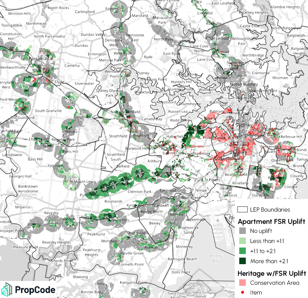
The non-discretionary standards for height and FSR for residential flat buildings and shop top housing will have a large impact, with nearly 75,000 lots across the Six Cities Region benefitting from these higher limits. Looking at aggregate totals, the higher FSRs would potentially allow up to 88 million sqm of additional GFA, averaging out to a 1.4:1 FSR uplift across all the affected lots. This additional GFA represents approximate new capacity for up to 1 million dwellings, although of course nowhere near that much will actually be built for numerous reasons.
The map below shows where this apartment FSR uplift is distributed around inner Sydney, with the degree of uplift in green shades. Properties that would have positive uplift but are affected by heritage are marked in red shades. Non-uplifted properties are in gray, including those with no existing FSR control.
It won't be surprising to see aspects of this proposal whittled down, but some substantial amount of change is likely to go ahead.
Check out PropCode
Check out the PropCode platform including our Library and CDC tools that help users get answers from planning regulations.